Article Title
Abstract or Description
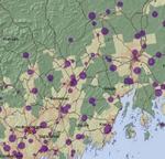
Cell phones are quickly becoming a necessary tool for personal and commercial use. Shown here is the distribution, as well as the relative sizes, of towers located in the state of Maine. The population layer illustrates these towers' relation to high densities of people. The roads on the map indicate major state roads, and they illustrate the proximity of towers to these roads. The patterns of distribution and location have direct implications for the movement of people, the expansion of development, and growth of business in Maine.
Source Data Note
All data projected in Universal Transverse Mercator, Zone 19, and using the North American Datum 1983. Census block population data was obtained from the Environmental Solutions and Research Institute (ESRI). The cell phone tower data, county outlines, hillshade, and public roads layers were all obtained from the Maine Office of GIS website (http://megis.maine.gov/catalog/).
Rights
Recommended Citation
Mcevoy, Andy ('09) "Cell Phone Tower Location and Size in Maine," Atlas of Maine: Vol. 2009: No. 1, Article 11.Available at: https://digitalcommons.colby.edu/atlas_docs/vol2009/iss1/11