Article Title
Abstract or Description
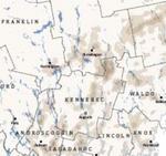
This map shows cropland in Maine in relation to the state’s aquifers. Cropland is displayed as the percentage of land covered by crops and pasture within a 2.5 km radius of any point.
Source Data Note
Cropland Layer from 2001 NLCD Land Cover Data from the National Map (http://nmviewogc.cr.usgs.gov/viewer.htm), Aquifers from the Maine Office of GIS (http://megis.maine.gov/), Borders and Coastlines from Maine Office of GIS (http://megis.maine.gov/), Gulf of Maine Institute (http://www.gulfofmaine.org/), ESRI, Inc. 9.3 and County and State Borders from Maine Office of GIS (http://megis.maine.gov/)
Rights
Recommended Citation
Ambrogi, Michael ('09) "Maine: Cropland and Aquifers," Atlas of Maine: Vol. 2009: No. 1, Article 1.Available at: https://digitalcommons.colby.edu/atlas_docs/vol2009/iss1/1
COinS