Abstract or Description
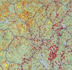
The purpose of this map is to convey the extent of fragmentation in Maine's forests. I chose this particular area to show the immediate effects of logging roads and clearcutting on a local scale. The data were used to focus on current, cleared, and regenerating forest locations as of 2005. A raster layer from the National Atlas database of National Land Cover Data assesses the magnitude of forest fragmentation due to human activities. Roads were also included to emphasize the development of roadways as a cause of fragmentation.
Source Data Note
Maine Office of GIS, U.S. Fish and Wildlife Service, National Atlas Projection: Clarke 1866, U.S. National Atlas Equal Area
Rights
Recommended Citation
Dreiss, Lindsay ('09) "Fragmentation and Clearing of Maine Forest Habitats, 2005," Atlas of Maine: Vol. 2008: No. 1, Article 6.Available at: https://digitalcommons.colby.edu/atlas_docs/vol2008/iss1/6
COinS