Article Title
Source Data Note
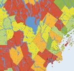
Property value 1999-2008 data obtained from the Maine State Planning Office. Map projected under UTM Zone 19N, with NAD83 Datum.
Rights
Recommended Citation
Darling, Beth ('08) "Changing Property Values in Maine 1999-2008," Atlas of Maine: Vol. 2008: No. 1, Article 5.Available at: https://digitalcommons.colby.edu/atlas_docs/vol2008/iss1/5
COinS