Article Title
Abstract or Description
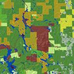
This map shows woodlot ownership in Maine. It differentiates between varying forms of private and public, as well as industrial ownership.
Source Data Note
The layers displaying hillshade and water features are provided by the Maine office of GIS. The layer displaying woodlot ownership is provided by the James W. Sewall Company. The map is projected in UTM zone 19, NAD 83.
Rights
Recommended Citation
Tyson, Will ('09) "Woodlot Ownership in Maine," Atlas of Maine: Vol. 2008: No. 1, Article 15.Available at: https://digitalcommons.colby.edu/atlas_docs/vol2008/iss1/15
COinS