Article Title
Abstract or Description
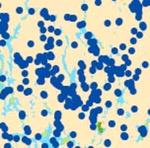
The Aquifers and Wells of Maine map was created by downloading data from the Maine Office of GIS. The data indicate where wells and aquifers are located as well as the quantity of water within aquifers. This map is a resource to evaluate the current debate over groundwater withdrawal in Maine.
Source Data Note
Data provided by the Maine Office of GIS (http://apollo.ogis.state.me.us/)
Rights
Recommended Citation
Kelly, Sarah ('06) "Aquifers and Wells of Maine," Atlas of Maine: Vol. 2006: No. 1, Article 3.Available at: https://digitalcommons.colby.edu/atlas_docs/vol2006/iss1/3
COinS