Article Title
Abstract or Description
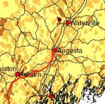
This map is a spatial analysis of Maine's population by census block (in 2000) and the locations of highways/major roads within the state.
Source Data Note
The 'Major Roads' and the 'Population Density' layers were obtained from the online Maine Office of GIS Data Catalog. The 'Cities with 9,000 or more residents' layer was obtained from ESRI.
Rights
Recommended Citation
Weeks, Sam ('06) "'Omes and Cahs: The Locations of Mainers and Their Roads," Atlas of Maine: Vol. 2006: No. 1, Article 16.Available at: https://digitalcommons.colby.edu/atlas_docs/vol2006/iss1/16
COinS