Article Title
Abstract or Description
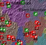
This map of current and former Maine ski areas was developed from data on the New England Lost Ski Areas Project Web page (www.nelsap.org). It documents ski areas that are closed as well as currently open ski areas overlain on top of Maine county outlines obtained from the Maine Office of GIS.
Source Data Note
The ski area data presented on this map is documented on the New England Lost Ski Areas Project Web page (http:\\www.nelsap.org) and was compiled by Chris Russoniello. The background hillshade layer was obtained from the Maine Office of GIS.
Rights
Recommended Citation
Russoniello, Chris ('06) "Maine Ski Areas: Past and Present," Atlas of Maine: Vol. 2006: No. 1, Article 13.Available at: https://digitalcommons.colby.edu/atlas_docs/vol2006/iss1/13
COinS