Article Title
Abstract or Description
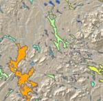
This map was created using data from Public Education Access to Environmental Information in Maine (PEARL) and the Maine Office of GIS. The map shows the abundance of fish species in the Department of Fish and Wildlife surveyed Maine lakes. The fish densities were matched with their respective Maine lakes based on Maine Information Display and Analysis System (MIDAS) numbers. A hillshade background was added to provide better perspective on lake locations. Finally the Maine streams and rivers layer from the Maine Office of GIS was added to fill in hydrological gaps in the data.
Source Data Note
Data provided by: Maine office of GIS (http://apollo.ogis.state.me.us/catalog/), PEARL (http://pearl.spatial.maine.edu/). Data compiled by Whitney King.
Rights
Recommended Citation
Crowley, Richard ('05) "Fish Density in Maine Lakes," Atlas of Maine: Vol. 2005: No. 1, Article 2.Available at: https://digitalcommons.colby.edu/atlas_docs/vol2005/iss1/2
COinS