Article Title
Abstract or Description
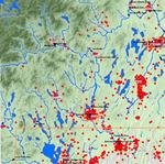
This map shows the fault lines in the state of Maine, and represents the locations and magnitudes of all the earthquakes that have occurred in the state of Maine from 1568 to 2005. It also includes the earthquakes that occurred outside of Maine but that may have been felt in Maine.
Source Data Note
This map was made using NAD83 and UTM zone 19. The fault line and counties of Maine layers come from the Maine Office of GIS. The earthquake data is from the Boston College, Northeast Earthquake Catalogs. The intensity of the earthquakes were not all in the Modified Mercalli Intensity Scale; some were in the Nuttli Magnitude Scale. Using the description of the two scales from the U.S. Geological Survey, I converted the Nuttli Magnitude to the Modified Mercalli
Rights
Recommended Citation
Dufraine, Caitlin ('09) "Fault Lines and Earthquakes of Maine, 1568-2005," Atlas of Maine: Vol. 2008: No. 1, Article 7.Available at: https://digitalcommons.colby.edu/atlas_docs/vol2008/iss1/7
COinS