Article Title
Abstract or Description
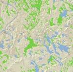
This map shows the distribution of wetlands in comparison to areas of development in Maine.
Source Data Note
Maine Office of GIS. http://apollo.ogis.state.me.us/catalog/catalog.asp Wetland Data: 1998. Impervious Surfaces: 2004. UTM Zone 19, NAD 1983
Rights
Recommended Citation
Clark, Alaina ('08) "Wetlands and Development in Maine," Atlas of Maine: Vol. 2008: No. 1, Article 4.Available at: https://digitalcommons.colby.edu/atlas_docs/vol2008/iss1/4
COinS