Article Title
Abstract or Description
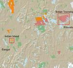
This map shows the land holdings of the State’s three federally recognized tribes: Malaseets, Passsamaquoddy, and Penobscot. In addition, it highlights statewide public conservation land and lakes in order to represent the close relationship between tribal and conservation lands. Two insets display a close-up of social services like schools, fire stations, and police stations located in and near Passamaquoddy and Penobscot reservations.
Source Data Note
Maine Office of GIS, ESRI Data Maps Version 9.2, and Manny Gimond. Projection: NAD1983, UTM Zone 19N
Rights
Recommended Citation
Casey, Caitlin ('09) "Federally Recognized Indian Lands of Maine," Atlas of Maine: Vol. 2008: No. 1, Article 3.Available at: https://digitalcommons.colby.edu/atlas_docs/vol2008/iss1/3
COinS