Article Title
Abstract or Description
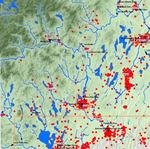
This map shows population density, river systems, and dam placement in the state of Maine. Each randomly-placed dot represents 100 people per square mile. The dams shown are those whose main purpose is the production of hydroelectric power.
Source Data Note
Projected Coordinate System: NAD_1983_UTM_Zone_19N. Data gathered from the Maine Office of GIS, The Berkeley/Penn Urban & Environmental Modeler's Datakit, ESRI, and the U.S. Census Bureau.
Rights
Recommended Citation
Freudenberger, Fritz ('09) "Population Density and Dams in Maine, 2000," Atlas of Maine: Vol. 2008: No. 1, Article 8.Available at: https://digitalcommons.colby.edu/atlas_docs/vol2008/iss1/8
COinS