Abstract or Description
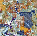
This map shows levels of wildlife habitat suitability in relationship to Maine's conservation lands. The habitat suitability values are based on 91 priority trust species of the U.S. Fish and Wildlife Service. The habitats for each species were mapped and ranked from actual sightings or by developing habitat suitability models reflecting environmental requirements for each species. Scores for each species were then added to derive the sum of scores for all species combined.
Source Data Note
Maine Office of GIS (http://apollo.ogis.state.me.us/catalog/), James W. Sewall Company (http://www.jws.com/). Data compiled by Bob Houston of the U.S. Fish and Wildlife Service, Gulf of Maine Program (habitat suitability) and Web Forest Resource Information Systems (conservation areas). Date of data: December 2004 (habitat suitability), September 2007 (conservation areas)
Rights
Recommended Citation
Presby, Michelle ('09) "Suitable Habitats for Wildlife and Conservation Areas in Maine," Atlas of Maine: Vol. 2008: No. 1, Article 13.Available at: https://digitalcommons.colby.edu/atlas_docs/vol2008/iss1/13