Article Title
Abstract or Description
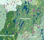
Organic Farms and Agricultural Chemicals in Maine shows the percentage of land treated by pesticides, herbicides, fungicides, and other chemicals in each of the sixteen counties in Maine.
Source Data Note
These data are based on the 2000 Agricultural Census of the United States Department of Agriculture and reflect the level of chemical application in 1997. The yellow area on the map represents the regions of land devoted to agriculture from 1999 to 2001. In this case agriculture includes cultivated crops, hay and pasture lands, and blueberry fields. The dots on the map symbolize farms that were certified organic by the Maine Organic Farmers and Gardeners Association in 2007. Each dot represents one certified farm. The dots do not represent the exact location of the farm, rather they were randomly placed within the farm's township.
Rights
Recommended Citation
Becker, Rose ('08) "Organic Farms and Agricultural Chemicals in Maine," Atlas of Maine: Vol. 2008: No. 1, Article 1.Available at: https://digitalcommons.colby.edu/atlas_docs/vol2008/iss1/1