Abstract or Description
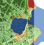
Maine's 3,500 miles of coastline is the longest coastline in the continental US. The goal of our study was to use GIS to estimate the impact future global sea level rise could potentially have on our state. We show the area of coastline and some of the economic and social impacts that would result from a rise of one meter and six meters. We used roads to estimate the impact on infrastructure and public building, including schools, libraries, hospitals, police and fire stations, as a measure of social impact. A sea level rise of six meters would result in a loss of over 650 km¬2 from coastal communities and cost the state of Maine over 3 million in repaving costs. Through our study, we hope coastal communities will be able to prepare for and react to the predicted changes in global sea level.
Rights
Recommended Citation
Capponi, Randa ('06); LaShoto, Gregory ('07 J); McMonagle, Sharon ('06); and Russoniello, Christopher ('06) "Estimating the Impact of Catastrophic Sea Level Rise in Maine," Atlas of Maine: Vol. 2006: No. 2, Article 1.Available at: https://digitalcommons.colby.edu/atlas_docs/vol2006/iss2/1