Article Title
Abstract or Description
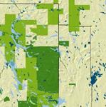
This map shows the location of wetlands and the location of conservation lands. The conservation lands are categorized based on land ownership including state-owned, federally-owned, and privately-owned lands.
Source Data Note
MECNSLND shows private, state, and federal conservation lands in Maine, Maine State Planning Office, 2003. HYD24 shows major rivers and streams in Maine, U.S. Geological Survey and Maine Office of GIS, 2004. WETDLG: wetland locations in Maine, U.S. Geological Survey and Maine Office of GIS,1991. CNTY24P shows county boundaries in Maine, Maine Office of GIS, 2005.
Rights
Recommended Citation
Cleaver, Cait ('06) "Wetlands and Conservation Lands of Maine," Atlas of Maine: Vol. 2006: No. 1, Article 2.Available at: https://digitalcommons.colby.edu/atlas_docs/vol2006/iss1/2
COinS